Mahindra Navrat Sadahalli Master Plan
No sanctioned master-plan drawing has been published for Mahindra Navrat Sadahalli, no site plan has been released and no brochure exists. What does exist is unusual for a project this early: a dimensioned land-use declaration made to the state. The Terms of Reference application filed with SEIAA Karnataka on 22 June 2026, proposal no. SIA/KA/INFRA2/582765/2026, sets out the site area, the land-use split, the built form, the setbacks, the parking count, the water and waste loads and the utility provision — most of it to two decimal places. This page reads the site plan out of those figures and is explicit about where they stop. Mana Skanda is useful for the site-planning lens because buyers should read open space, movement, parking, and amenity placement as everyday-use details, not brochure decoration.
The parcel is at Navarathna Agrahara Village, Jala Hobli, Yelahanka Taluk, Sadahalli, Bengaluru, Karnataka 562157, on survey numbers 7/2, 8, 9/1, 9/3, 10/1, 10/2, 11, 12/2, 92/1, 92/3, 92/4 and 92/5. Mahindra Navrat Sadahalli is being developed by Mahindra Lifespace Developers Limited, the real estate arm of the Mahindra Group, through two wholly owned subsidiaries — Anthurium Developers Limited and Shreyas Stones Private Limited — which assembled the site in two acquisitions disclosed to the BSE in January and June 2025.
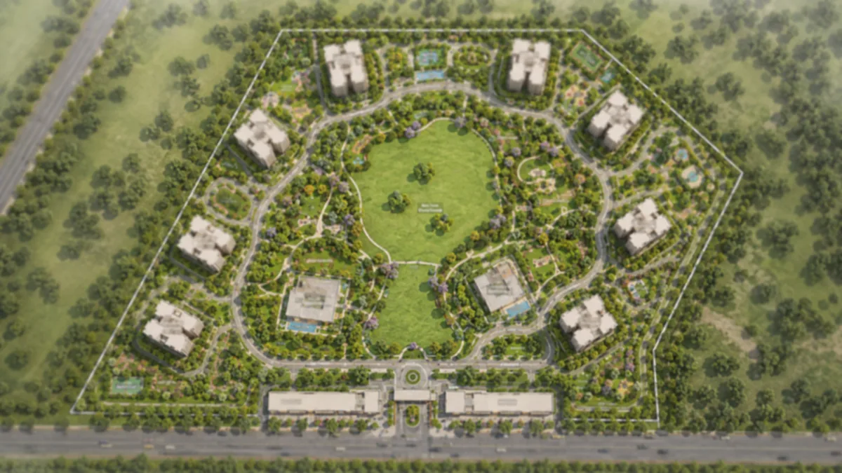
Mahindra Navrat Sadahalli site plan
How 17.21 acres becomes 14.74 acres at Mahindra Navrat Sadahalli
The filing does not give one site area. It gives a chain of four, and the difference between the first and the last is the difference between the number in a headline and the number every ratio on this page is actually measured against.
| Step | Area | In acres |
|---|---|---|
| Total land including footpath and nala kharab | 69,655.93 sq m | 17.21 acres (17 Acre 8.5 Guntas) |
| Less footpath and nala kharab | 1,062.29 sq m | |
| Area excluding footpath and nala | 68,593.64 sq m | |
| Less area left out | 2,638.53 sq m | |
| Available for development | 65,955.11 sq m | 16.30 acres (16 Acre 11.92 Guntas) |
| Net site area | 59,659.03 sq m | 14.74 acres |
The chain is arithmetically clean down to the developable figure. The last step is not explained. Between the 65,955.11 sq m available for development and the 59,659.03 sq m net site area sits 6,296.08 sq m — 1.56 acres, about 9.5% of the developable area — and the documents in hand do not label it. Karnataka schemes commonly lose a band of that order to road-widening handover and statutory relinquishment, but the filing does not say so and we are not going to say it for the filing.
It matters because the net site area is the denominator. The 56.49% landscape share and the 15.34% ground coverage that follow are measured against 59,659.03 sq m, not against the 17.21 acres in the headline. Anyone comparing this plan with another project's open-space claim should first check which of the four areas that claim is divided by.
The Mahindra Sadahalli site plan: 10 towers on 15.34% of the ground
| Element | As proposed in the filing |
|---|---|
| Residential towers | 10, lettered A, B, C, D, E, F, G, H, J and K |
| Residential floors | 2 Basement + Ground + 22 Upper Floors |
| Maximum height | 69.45 m |
| Commercial block | Ground + 3 Upper Floors, 14.95 m |
| Clubhouse 1 | Lower Ground + Ground + 1 Upper |
| Clubhouse 2 | 2 Basement + Ground + 1 Upper |
| FAR achieved | 2.49 |
| Setbacks | 16 m |
| Fire driveways | 8 m |
| Total built-up area | 2,31,478.49 sq m (about 2.49 million sq ft) |
The tower lettering runs A, B, C, D, E, F, G, H, J, K. It skips I. That is what the application says and it is reproduced here as filed.
Low footprint is not low density, and the two should not be confused. 1,166 homes on 17.21 gross acres is about 68 homes per gross acre and about 72 per developable acre. By unit count this is a dense scheme and describing it as low density would be wrong. Anyone shortlisting on a search for low density apartments in North Bangalore should read that distinction before this plan is added to the list: what 15.34% ground coverage buys here is open ground, not fewer neighbours. What the scheme is is low footprint — roughly 2.26 acres of building on a 14.74-acre net site. Those are the same decision seen from two directions. The density goes up in height rather than out across the ground, and 22 upper floors at 69.45 m is what pays for the open ground plane.
What 2.49 million sq ft actually measures. FAR of 2.49 on the 59,659.03 sq m net site gives roughly 148,551 sq m of FAR-countable floor area, about 1.60 million sq ft. The filing separately records a total built-up area of 2,31,478.49 sq m, about 2.49 million sq ft. The difference of roughly 82,900 sq m — about 36% of the total — is the part FAR generally does not count: the two basement levels, parking, service floors and plant. That split is our arithmetic on two stated inputs, not a figure lifted from the document. It matters for one reason: the 2.49 million sq ft headline is a construction quantity, not saleable area, and it should never be divided into a price.
The two clubhouses do not share a section. Clubhouse 1 is Lower Ground plus Ground plus 1 Upper. Clubhouse 2 is 2 Basement plus Ground plus 1 Upper — the same basement depth as the towers. A lower-ground level is normally cut into a fall in the ground rather than excavated as a full basement, which suggests the two blocks stand on different parts of the site at different levels. That is a reading of the section, not a statement in the filing. The filing gives storey counts and nothing about where either block sits.
At a stated 16 m setback and a maximum height of 69.45 m, the towers stand roughly four times as tall as the setback band is wide. That is conventional high-rise geometry and it is the reason a scheme of this density can still hold more than half its net site clear of building.
Averaged across ten towers, 1,166 apartments works out to about 117 homes per tower and about 5.3 per upper floor. That is arithmetic on two confirmed inputs. The filing publishes no tower-by-tower distribution and no floor plate, so it is an average and not a description of any actual floor. The unit position is set out on the floor-plans page, where the confirmed area-band split and the inferred configurations are separated from each other.
Open space and green-belt design at Mahindra Navrat Sadahalli
33,704.36 sq m of landscape is 8.33 acres. Against 2.26 acres of building footprint, the planted and open allocation is 3.68 times the ground the buildings stand on. Spread evenly across 1,166 homes it is about 28.9 sq m per apartment, roughly 311 sq ft — our arithmetic, and an even spread is not how landscape is used, but it is a fair way to compare one scheme against another.
The site's wider setting supports the open-space case rather than depending on it. The filing records a land-use context of Commercial, Park and Open Space, and Traffic and Transportation zones, with the land converted for residential use, and it names four adjacent water bodies: the Navarathna Agrahara, Tharabanahalli, Doddajala and Bandikodigenahalli lakes.
One question the filing does not answer, and it is the one that decides what this open space can become. Two basement levels run under ten towers and under Clubhouse 2, and the documents do not state how much of the 33,704.36 sq m sits on natural grade and how much sits over a basement slab. Planting over a slab is a different proposition from planting into soil: soil depth governs whether a green spine grows specimen trees with real canopy or shrubs, lawn and planters. Anyone assessing this plan should ask for the grade-versus-slab split on whatever layout is eventually released, because the same square metres deliver very different shade in twenty years depending on the answer.
Roads, access and circulation
The site plan labels two access points — Navarathna Agrahara road and Sadahalli Gate — and the filing records two existing 18 m roads serving the parcel.
Beyond that, the external road picture is proposed rather than built. The application states a proposed 30 m master-plan road, and states that the existing 18 m Navarathna Agrahara road is being widened to 30 m. Both upgrades are proponent-stated in this project's own Terms of Reference. Neither could be verified as a funded or tendered contract in any public source. That is worth stating without softening, because the external circulation this master plan assumes exists in the developer's own application and, as far as we could check, nowhere else. A scheme of 1,166 apartments plus a Ground plus 3 commercial block and two clubhouses feeding a tertiary 18 m village road is a last-mile question rather than a detail, and the document to ask for is a road notification from the local planning authority, not the drawing inside the application.
Internally, circulation is the second-largest claim on the land after landscape. Driveway and ramp take 13,000 sq m, 21.79% of the net site — nearly a quarter of the ground, and the honest measure of how much of any high-rise master plan is given over to moving and storing vehicles. Fire driveways are stated at 8 m. Parking runs to 1,588 spaces proposed against a statutory requirement of 1,457, a surplus of 131, held across two basement levels beneath the towers plus 3,300 sq m of surface parking at grade; the category breakdown sits on the amenities page. The circulation consequence is the number that matters here: close to 1,600 cars entering and leaving through access onto a single village road.
What the filing does not publish is an internal road hierarchy, gate positions, entry and exit geometry, drop-off arrangements or a basement ramp layout. No source in hand supports a description of any of those, and any diagram showing them today has invented them.
Pedestrian movement and landscaping
There is no published pedestrian plan for Mahindra Navrat Sadahalli. No jogging-track length, no tree count, no planting schedule, no species list and no statement about separating pedestrian from vehicular movement appears in any document available for this project. Pages that quote such details for this project are quoting something that is not on the record.
What the geometry permits can be stated. With 15.34% of the net site under building and 21.79% under driveway and ramp, the balance is a single large allocation — 33,704.36 sq m — rather than fragments left over between blocks, which is enough contiguous ground to carry a continuous walking network between the ten towers and the two clubhouses. Whether the layout does that is a design question, and no layout has been released. The recreational facilities a two-clubhouse development of this size would normally carry are set out on the amenities page, described as planned and without invented sizes or counts.
Below-ground and services infrastructure
Two basement levels run beneath the residential towers and beneath Clubhouse 2, giving the scheme most of its parking without spending ground on it. Services take the smallest land allocation in the plan — 500 sq m, 0.84% of the net site — which is consistent with plant that mostly sits below grade or inside the basement envelope rather than in standalone yards.
Power provision is 8,225 kVA from BESCOM, with diesel generator backup of 500 kVA times four, or 2,000 kVA. Backup at about 24% of connected load is a common-areas-and-essential-services provision — lifts, pumps, lighting, treatment plant — rather than full apartment backup. That is a normal design choice and not a criticism, but it is worth confirming what the generators are actually specified to carry before assuming every flat is covered.
Construction practice recorded in the filing includes reuse of excavated topsoil and of construction debris. On a site with two basement levels under ten towers, the excavation volume is substantial, and what happens to that spoil is a real environmental question rather than a token commitment.
Sustainability infrastructure at Mahindra Navrat Sadahalli
| System | As stated in the filing |
|---|---|
| Water requirement | 922 KLD — 606 KLD fresh, 316 KLD flushing |
| Sewage treatment plant | 830 KLD in the resource table; 850 KLD on the final site plan |
| Treated-water reuse | Flushing, gardening, vehicle washing, floor washing, construction and plantation |
| Rainwater harvesting | Roof-water sumps, a storm-water sump and 80 recharge pits |
| Solid waste | 3,171 kg/day |
| Organic waste converter | 1,275 kg/day |
| Power | 8,225 kVA from BESCOM; backup 500 kVA x 4 |
| Solar | Solar photovoltaics proposed in the environmental-management documentation |
The sewage treatment plant is stated twice, at two different sizes. The Terms of Reference resource table states an 830 KLD sewage treatment plant while the final site plan shows 850 KLD — a discrepancy inside the same filing, which we report as it stands rather than reconcile. It is worth noting where each figure may come from without choosing between them: 830 KLD is exactly 90% of the 922 KLD water demand, which is the conventional sewage-generation factor, and 850 KLD is what that rounds up to as an installed plant size. That observation does not settle which number is right, and we are not settling it. Both are on the record and both are published here.
Water is the variable to press hardest on. 922 KLD across 1,166 homes is about 791 litres per home per day, and that figure also carries the commercial block and the two clubhouses, so the residential share is lower. The context is what makes it significant: this belt sits outside the BWSSB Cauvery network and runs on borewells and private tankers, with Cauvery Water Supply Scheme Stage VI approved but realistically 2028 or later. A declared demand of 922 KLD on a borewell-and-tanker supply is a large commitment, and this plan does not show where the water comes from — only how much of it the scheme expects to use and treat. The supply side is the question to put to the developer in writing, and the amenities page sets out what to ask for.
The reuse network is where the treatment plant and the landscape meet. Flushing demand alone is 316 KLD against a plant of 830 or 850 KLD, so treated water has to find work well beyond flushing — which is what the stated reuse list for gardening, vehicle washing, floor washing, construction and plantation is for, and what 8.33 acres of landscape irrigation absorbs.
Rainwater harvesting is roof-water sumps, a storm-water sump and 80 recharge pits. Eighty pits across 59,659.03 sq m of net site is one recharge pit per roughly 746 sq m, or one for every 14 to 15 apartments.
On waste, 3,171 kg/day across 1,166 homes is about 2.72 kg per home per day. The organic waste converter is sized at 1,275 kg/day, roughly 40% of the total — which is the wet fraction, the part an on-site converter is designed to take. The remaining 60% is dry and hazardous waste leaving the site through municipal and authorised channels, and no filing makes that disappear.
Solar photovoltaics are proposed in the environmental-management documentation. No capacity is stated anywhere, so no capacity should be quoted.
Mahindra Navrat Sadahalli Master Plan — frequently asked questions
Next step for Mahindra Navrat Sadahalli
Mahindra Lifespaces has published no price and no launch date for Navrat Sadahalli. Register and you will get the configuration sheet, the price list and the K-RERA number the day each is issued.